Carnic high trail: The peace trail (+Guide and GPX)
- Christian Sommer
- Nov 3, 2023
- 12 min read
Updated: Mar 22
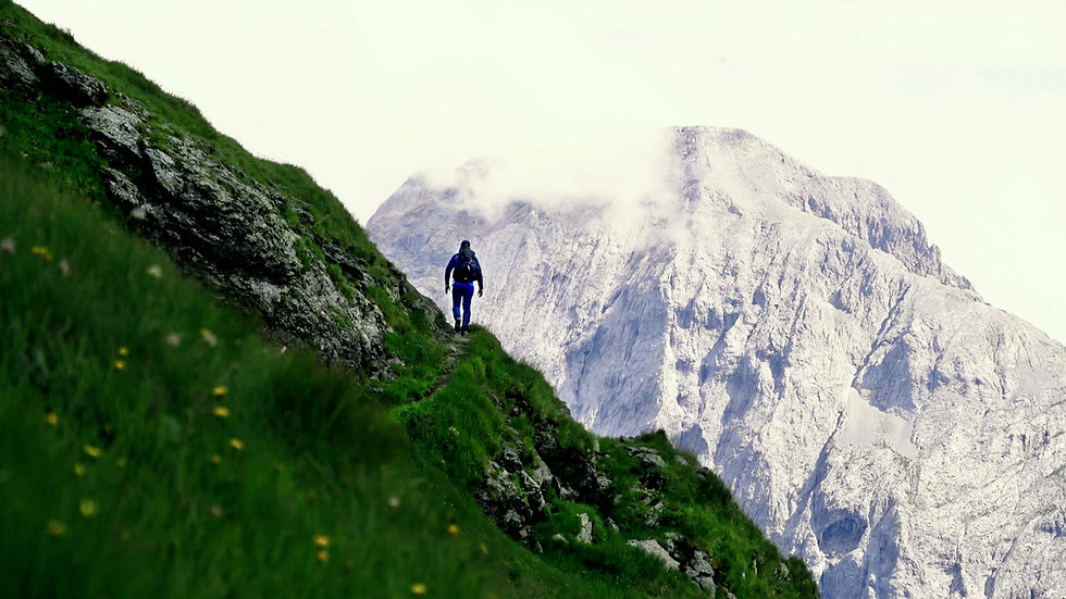
The Carnic High Trail, also known as the Peace Trail, is a hiking trail steeped in history through the majestic Carnic Alps. Its magical blend of alpine tranquillity, impressive vastness and historical significance is unique. You embark on an unforgettable journey across the peaks and valleys of this breathtaking mountain range and experience the silent history of the past that is anchored in this landscape. Remains of fortifications and trenches from the First World War are reminders of past conflicts. I thought the tour was fantastic. Chapeau!
Contents
1. Arrival
2. Route
3. Accommodation
4. Weather and best time to travel
5. Further information
6. Recommended stages
7. Packing list
8. GPX and map information
9. Conclusion
Carnic high trail: Karnischer Höhenweg
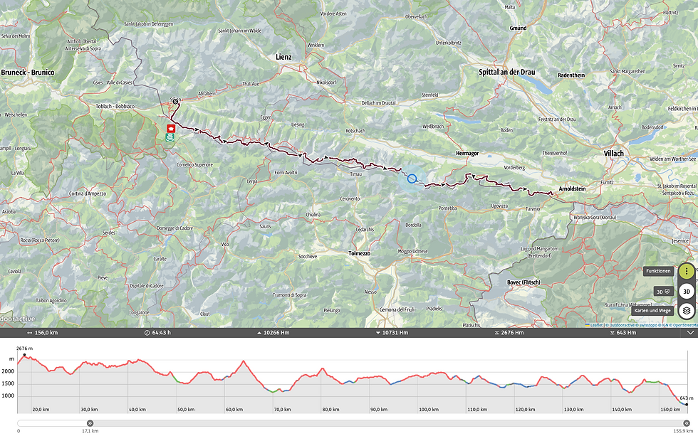
Is a hiking trail (trail no. 403) in the Carnic Alps, which runs in several variants along the state border between Italy and Austria in large parts at the height of the Carnic main ridge. It passes nine mountain huts and has a total length of around 155 kilometres. I don't think there is a comparable high-altitude trail in the world that runs so stringently along the summit ridge. A real treat!

Carnic high trail arrival
By train: Sillian is well connected to the railway network. You can take a train to Sillian and then walk from the railway station to the starting point of the Carnic High Trail. I started the tour at the main square in Sillian. I highly recommend the OMIO app for booking bus and train tickets.
By car: You can drive to Sillian by car. Be aware that there can be traffic jams in high season, especially in the summer months when many hikers and tourists visit the region. There are free car parks at the train station.
By plane: The nearest airports are Innsbruck Airport (INN) and Klagenfurt Airport (KLU). From there you can get to Sillian by public transport or hire car. I highly recommend using Skyscanner to find cheap flights – it's a great app that gives you a quick overview of the best flight deals. Here you will find an overview of all the relevant airports for your journey.
As always, I recommend my video about the tour:
Carnic high route
There are different variants and sections of the Carnic High Mountain Trail, depending on your fitness level, your preferences and the time you have available. I will show you the most popular variants below:
The classic Carnic High Route: This is the main route of the Carnic High Route and stretches for around 150 kilometres from Sillian in Austria to Arnoldstein. You have to conquer around 10,000 metres in altitude.
Alpine section: The alpine section of the tour is from Sillian to the Plöckel Pass. After that, the high-level trail largely loses its alpine character. However, this does not make it any less beautiful!
Variants with summit ascents: There are also variants of the Carnic High Route that include ascents of peaks such as the large Kinigat or the Rauchkofel. These routes require more time, planning and, in some cases, mountaineering experience.

Carnic high trail stages
6 stages (alpine part for connoisseurs):
Stage 1: Sillian - Sillianer Hütte: approx. 8km and 1344 metres altitude difference
Stage 2: Sillianer hut - Obstansersee hut: approx. 10 km and 505 metres altitude difference
Stage 3: Obstansersee hut - Porzehütte hut: approx. 13 km and 1060 metres altitude difference
Stage 4: Porzehütte - Hochweißsteinhaus: approx. 17 km and 1300 vertical metres
Stage 5: Hochweißsteinhaus - Wolayerseehütte: approx. 17 km and 1000 metres altitude difference
Stage 6: Wolayerseehütte - Plöckenpass: approx. 7 km and 250 metres difference in altitude
9 stages for connoisseurs (155 km):
Stage 1: Sillianer hut - Obstansersee hut: approx. 10 km and 505 metres altitude difference
Stage 2: Obstansersee hut - Porzehütte hut: approx. 13 km and 1060 metres altitude difference
Stage 3: Porzehütte - Hochweißsteinhaus: approx. 17 km and 1300 vertical metres
Stage 4: Hochweißsteinhaus - Wolayerseehütte: approx. 17 km and 1000 metres altitude difference
Stage 5: Wolysersee-Hätte - Untere Valentin Alm: approx. 2.5 hrs.
Stage 6: Untere Valentin Alm - Zollnersee Hütte: approx. 6.5 hrs.
Stage 7: Zollnersee Hütte - Straniger Alm: approx. 3 hrs.
Stage 8: Straniger Alm - Alpenhof Plattner: approx. 6.5 hrs.
Stage 9: Alpenhof Plattner - Egger Alm: approx. 4.5 hrs.
Stage 10: Egger Alm - Gasthaus Starhand: approx. 3.5 hrs.
Carnic high trail 5 days
5 stages for sporty hikers:
Stage 1: Sillian - Sillianer Hütte: approx. 8km and 1344 metres altitude difference
Stage 2: Sillianer Hütte - Porzehütte: approx. 23 km and 1600 metres altitude difference
Stage 3: Porzehütte - Hochweißsteinhaus: approx. 17 km and 1300 metres of ascent
Stage 4: Hochweißsteinhaus - Wolayerseehütte: approx. 17 km and 1000 m altitude difference
Stage 5: Wolayerseehütte - Plöckelpass: approx. 7 km and 200 metres difference in altitude

Carnic high trail guide
Day 1: You start in the picturesque village of Sillian on the main square. The atmosphere there immediately inspired me - you meet hikers, mountaineers and mountain bikers everywhere. A great feeling! Your adventure begins with a steady hike uphill to the Sillianer Hut, where the first impressive view of the Sesto Dolomites awaits you. Follow the Heimatsteig 403 trail, which takes you over the Leckfeldalm.
Don't forget to take an emergency bivouac with you. It consists of an emergency blanket that is cold-resistant, a whistle and a mini compass. It should be in your rucksack on every hike anyway.
As the old Scottish saying goes: "There's no such thing as bad weather, only bad clothes!"
Take a look at the following pictures in the slider!


Day 2: The sun was already high in the sky when I started my hike on the Carnic High Trail. The cool mountain air enveloped me as I set off from the Sillianer Hut. The view back opened up a majestic panorama of the Alps, their peaks glowing in the golden morning light. A day full of adventure lies ahead! The path, lined with rugged rocks, winds its way over the mountain ridge. On the way, you pass remnants of times gone by. Lonely bunkers and weathered tracks remind you of the history of this area, which was once characterised by the turmoil of the First World War. A deep sense of connection with the past pervaded me as I imagined what stories these mountains might have to tell. At the end of the day, I sat in front of the Porzehütte, let my mind wander into the distance and was enveloped by the silence of the mountains. I felt at one with nature. I hope you feel the same way!
Due to the long distance and the sweaty altitude difference, I would like to recommend my ultra-light hiking gear at this point:
I would also like to recommend my beloved Salewa trekking shoes because of the mountain and jungle scenery and the challenging mountain trails:
"Only where you have been on foot have you really been". Quote Johann Wolfgang von Goethe
Day 3: From the Porzehütte hut, the route leads steadily uphill and downhill to the Hochweißsteinhaus. The trail takes you through picturesque landscapes, from green alpine meadows to rocky heights. With a bit of luck, you might even have an animal encounter with the horses, as I did. During the ascent, you can enjoy the breathtaking views of the surrounding mountains. Some steep passages are challenging, but can be mastered safely thanks to the well-secured sections. As there is hardly any shade on the entire Carnic High Trail and you are also exposed to the movement of the air all day long, I recommend my beloved ‘Piz Buin Mountain’ sun cream, as well as my ultra-light sun cap and wind blocker.
• Sun cap
"The sun also shines behind the clouds." Quote from Karl Friedrich Wilhelm Wander
Tip: The Hochweißsteinhaus not only offers comfortable accommodation, but also a place of peace and relaxation. Here you can enjoy Alpine cuisine characterised by regional traditions and ingredients that thrive in this mountain region. The beauty of nature and the tranquillity of the mountains make your stay particularly worthwhile. A worthwhile destination for you if you want to experience an authentic alpine environment and warm hospitality.
Take a look at the following pictures in the slider!


Day 4: From the Hochweißsteinhaus, the journey continues down to another jewel, the Wolayerseehütte. The trail winds its way through another picturesque mountain world characterised by wild flower meadows and rugged rocks. During the descent, you have the opportunity to admire the panorama of the surrounding peaks and breathe in the refreshing mountain air. The Wolayerseehütte welcomes you with rustic charm and warm hospitality. Here you can relax after your day's hiking and indulge in the culinary delights of Alpine cuisine. From hearty soups and homemade bacon dumplings to tantalising desserts - the Wolayerseehütte offers you authentic dishes prepared with fresh, regional ingredients.

Day 5: From the idyllic Wolayerseehütte, the trail leads over a short ascent to a saddle down to the Plöckenpass. The alpine section of the Carnic High Trail ends here, but you can extend your hike to Arnoldstein. Another impressive mountain world awaits you to discover in Nassfeld. Alternatively, you can also take the bus at the Plöcken Pass at around 11.30 am to continue your journey.
I was surprised by a thunderstorm halfway up. There was one second between thunder and lightning. Luckily, the time between lightning and thunder got longer, so the thunderstorm turned off! Thunderstorms can be dangerous, especially in the mountains. So follow the basic rules for behaviour during thunderstorms.

Carnic high trail accommodation
There are various huts and accommodation options available to hikers along the Carnic High Mountain Trail. Here are some of the huts along the Carnic High Mountain Trail:
Here is my hut recommendation:
Day1: Sillianer Hütte
Day2: Obstansersee hut
Day 3: Porze hut
Day4: Hochweißstein hut
Day5: Wolayersee hut
The alpine section of the Carnic High Trail ends when you reach the Plöckel Pass. However, the rest of the route is by no means unspectacular. It continues through a picturesque mountain world!
Day6: Zollnerseehütte
Day7: Straniger Alm
Day8: Alpenhof Plattner
Day9: Egger Alm
Tip: Most huts must be reserved online, as there are only limited sleeping places are available! On https://www.alpenverein.at/huetten/finder.php you will find all the Alpine Club huts and their contact details.
There is no luggage transfer available on the long-distance hiking trail.

Carnic high trail hut
Here you will find a list of the most important huts along the Carnic High Mountain Trail:
Untervellacher Hütte (Possibly suitable as a bivouac)
Wild camping: Is generally prohibited in Austria and only permitted in an emergency (bivouacking).
I recommend the workouts on my YouTube channel for optimal preparation for any tour:
Carnic high trail weather and best time to visit
The summer months from mid-June to mid-September are the most popular time to hike along the Carnic High Trail. At this time, the days are longest, the temperatures are milder and the snowmelt has largely cleared the hiking trails. The huts along the trail are open and you can enjoy the full splendour of the alpine landscape. Be aware, however, that the summer months are also the most touristy time, and the huts can be fully booked. It is advisable to book in advance.
Caution: Remember that conditions in the mountains can often change quickly. Regardless of the time of year, it is important to bring appropriate hiking equipment, weatherproof clothing and sufficient provisions.
If we want to travel far, we must first cross the near; if we want to ascend, we must start at the bottom. Konfuzius 551 BC - 479 BC

Karnischer Höhenweg further information
Cash: Only cash is accepted at the huts. For an overnight stay with half board and packed lunch, you should expect to pay approx. 80 euros per day as of 2023.
Catering: There are hot meals and plenty of food at every hut.
Mobile phone reception: I had reception almost all the time, even with LTE.
Water: Unfortunately, you won't always find it. Make sure your water container is always well filled. I usually had around 3 liters with me. Especially in the mountains, the water is significantly less. However, you should definitely take a Water filter with you. No matter how clear the water may be, it can still contain impurities such as animal excrement or dead animals. However, you can also boil the water.
Wildlife: There is a wide variety of wildlife in the mountains, including animals such as mountain goats and marmots. Keep a respectful distance from the animals and bear in mind that they are wild and can react unpredictably.

Solitude: Parts of the Carnic Alta Via can be remote and take you away from civilization and communication. Make sure you communicate with other hikers or hut operators and inform them about your plans.
Alpine experience: The Carnic Alta Via has challenging sections with steep climbs, exposed paths (rope-insured). Experience in mountain hiking, orienteering and safe walking in challenging terrain is necessary.
Surefootedness: To be safe on the trail, sure-footedness and the right footwear are the most important factors - after all, falls due to tripping and slipping are the most common cause of accidents when hiking. So remember: the right footwear and the right walking technique are therefore incredibly important. You are sure to find the right footwear in the article below!
Weather conditions: The weather conditions in the mountains can change very quickly. Sudden weather changes, fog, thunderstorms and drops in temperature are possible. It is important to pay attention to the weather forecasts, take appropriate clothing with you and react accordingly in the event of bad weather.
Please note: Snowfall can also occur in the summer months, albeit only rarely.
Carnic High Mountain Trail most beautiful section: The most beautiful section of the Carnic High Mountain Trail is certainly the alpine part from the Sillianer Hütte to the Plöckelpass. The trail winds along the ridge for long stretches.

Carnic high trail packing list
Here I present the most important hiking equipment that I personally own, have tested extensively and have also bought myself. I attach great importance to the weight, quality and price of my equipment. It should feel comfortable on longer tours and be light at the same time. I can also recommend the women's equipment as my wife uses it and it is essentially the same as the men's equipment.
Attention: Please note that the hiking equipment is general and should be adapted depending on the season and individual needs!
Advertising note: These product links are affiliate links. If you buy something through one of these links, I will receive a small commission without you having to pay more. This helps me to maintain my blog and you support me in my project, for which I am very grateful. Thank you very much!
Clothes
Hiking boots
Hiking shorts
Long hiking pants
Functional shirt
Hybridjacket
Fleece-jacket
Rain jacket
Functional underwear
Hiking socks
Other hiking equipment:
• Sun cap
Hiking backback (approx. 60 litres or as required)
by EXPED - unfortunately not available on Amazon.
• Backback - Ospray (was my old one and is also good)
Technology and orientation:
• Compass
• Headlamp
• GPS device or GPS watch if necessary
• Binoculars if necessary
Catering:
• Sweets to keep up morale :)
Health & first Aid:
• First Aid (small and light)
• Tape
• Bivouac
• Toilet paper
Other:
• Passport/Insurance certificate
• cash
• Gas cartridge
Film equipment:
• Camera
• Drone
• Tripod
• Clip

Carnic high trail GPX
The GPX files can be downloaded from the following providers.
Outdooractive: https://out.ac/3va4ft
Carnic high trail map
Long-distance hiking trails in Europe: 90 routes, all countries
Safety advice
Carnic high trail conclusion
With a length of almost 155 km, the Carnic High Trail (Karnischer Höhenweg) is a fantastic long-distance hiking trail that offers an incredible amount. It shows a cross-section of the beautiful Carnic Alps. I really enjoyed the tour! It's one of my favorite tours.en I wish you a great time and good luck ;)
As always, I would be delighted to receive feedback via one of my channels.
You are also welcome to leave me a comment here.

Hello, I am Christian, the chief globetrotter of this Site and an enthusiastic adventurer, hiker and filmmaker. I love to explore new paths and inspire people with them, and I love to share my hiking knowledge with you! You can also find my videos on YouTube! On my blog you can find tips for beginners and professionals on the greatest and most beautiful hiking tours there are. I want to encourage people to explore the world as a hiker, whether in the countryside, through the forest or in the mountains. True to the motto: If you haven't hiked, you haven't seen the world,
On my blog, I also write about hiking gear, the right summit training and nature conservation, as well as tips and information about hiking.
Commentaires