Iceland's Laugavegur Trail, also known as the ‘trail of the hot springs’ or Laugavegurinn, is one of the most beautiful hiking trails in the world. The hike leads right through the fascinating Icelandic highlands to the green south coast. I found the tour simply magnificent - chapeau!

Content
1. Journey
2. Route
3. Accommodation
4. Weather and best time to travel
5. Further information
6. Recommended stages
7. Packing list
8. GPX and map information
9. Conclusion
Laugavegur Trail Iceland
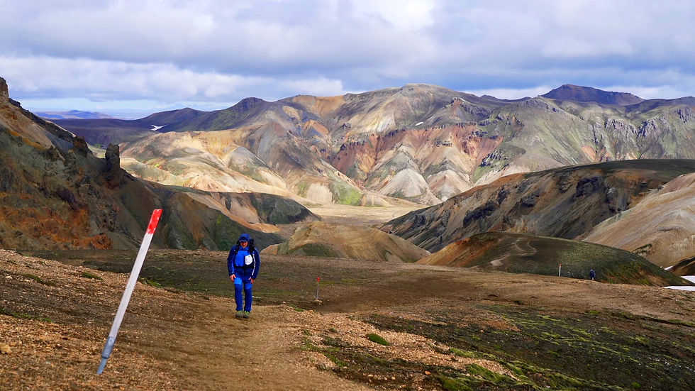
On the path of the hot springs, you will hike through a fascinating landscape of volcanic origin. The tour starts in Landmannalaugar, a geothermal, rainbow-coloured wonderland, and winds its way through deserts, green birch forests and past the majestic Eyjafjallajökull glacier. Amazing lava fields, glowing red and yellow rhyolite mountains, black sand and glistening white glaciers enchant you on the way to the south coast of Iceland.
As always, I recommend my video about the tour:
Laugavegur trail arrival
Flight: The best option is to take a flight to the Icelandic capital Reykjavik, to Keflavik Airport (KEF). I highly recommend using Skyscanner to find cheap flights – it's a great app that gives you a quick overview of the best flight deals. Here you will find an overview of all the relevant airports for your journey.
Bus: You can easily get to the city centre by bus. Alternatively, taxis are also available, but the prices are exorbitantly high. Travelling by bus in Iceland is very relaxed. The bus travels through almost the entire city and you can even tell the bus driver where you want to get off. I highly recommend the OMIO app for booking bus and train tickets.
Tip: The bus goes directly to the campsite in Reykjavik (Reykjavik Campsite). You will definitely get the cheapest place to sleep there. One night costs around 25 euros (as of 2022).
Tip: You can buy gas cartridges at the campsite for both screwing and stabbing. Many travellers also leave their used gas cartridges behind for others. There is a specially labelled shelf right outside reception for this purpose. A used gas cartridge was completely sufficient for my tour.

Tip: You can also buy a gas cartridge at the BSI Bus Terminal. You can make a note of the BSI Bus Terminal right away, it is an important contact point for many activities.


Laugavegur trek bus
I can highly recommend the ‘Highland Bus’. You can get the return journey for around 100 euros (as of 2022).
Bus to the trail: The next morning, it's best to take the Highland Bus from Reykjavik Excursion first thing in the morning. It starts at the BSI Bus Terminal and takes you to Landmannalaugar. You should book a ticket at the following link:
Tip: I recommend starting the hike in Landmannalaugar. From there, you walk downhill to Skógar, which saves you a few metres in altitude.

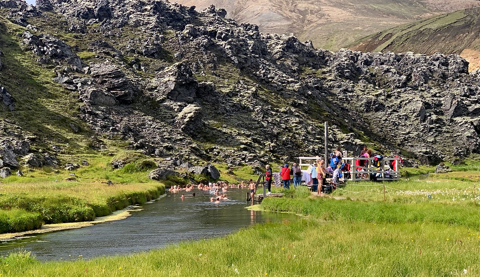
You reach Landmannalaugar around lunchtime. The journey by 4x4 bus was a fascinating adventure and the landscape is simply breathtakingly beautiful. I enjoyed every minute of it. You can then use the rest of the day for two shorter hikes at Bláhnúkur and Sudurnamur. There you will also find a small shop with food, a trekking camp and various local services. In general, there is a lot to discover in the area. In the late afternoon, I can highly recommend a dip in the hot springs located right next to the campsite. What can I say - it was an unforgettable experience!


Laugavegur trail route
In total, you cover around 80 km and around 2000 metres in altitude. I needed three days for the tour, which is quite sporty. For connoisseurs, I would recommend 4-5 days. On this tour, you can spend the night in a tent or in a hut. As always, early booking is highly recommended. There is a hut with refreshment facilities and a campsite approximately every 12 to 15 kilometres - you can find out more in the ‘Accommodation’ section.
Laugavegur trail stages
For connoisseurs I recommend:
Stage 1: Landmannalaugar - Hrafntinnusker approx. 11 km
Stage 2: Hrafntinnusker - Álftavatn approx. 12 km
Stage 3: Álftavatn - Emstrur approx. 16 km
Stage 4: Emstrur - Þórsmörk approx. 15 km
Stage 5: Þórsmörk - Fimmvörduskali approx. 14 km
Stage 6: Fimmvörduskali - Skogar approx. 15 km
You never have to climb more than 600 metres on this variant, which makes the hike very pleasant!
laugavegur trail 3 days
For the sporty I recommend:
Stage 1: Landmannalaugar - Álftavatn approx. 23 km
Stage 2: Álftavatn - Þórsmörk approx. 31 km
Stage 3: Þórsmörk - Skogar approx. 29 km
As already mentioned, I walked the 80km tour in 3 days.

Laugavegur trail guide
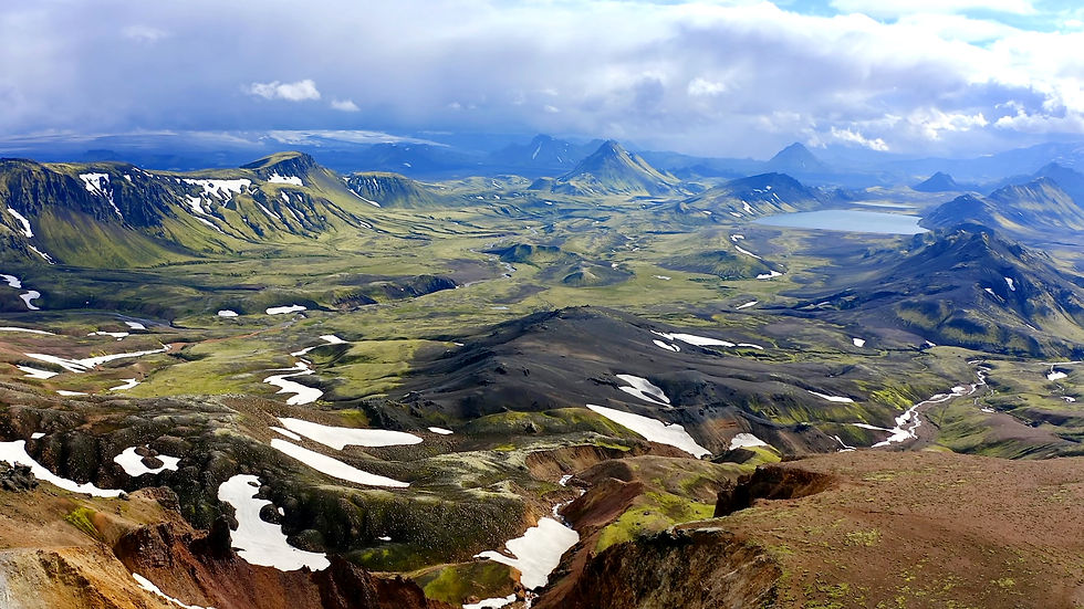
Day 1: Landmannalaugar is the starting point of the hike. The landscape here is characterised by rhyolite-coloured rock, active springs and numerous lava fields. An incredible play of colours surrounds you here. The sulphurous mist lends the scenery a mystical atmosphere. I found the sulphur crystals and the small geysers particularly fascinating. This impressive area touched me deeply - it was a wonderful experience to be able to immerse myself in this world. Once you have left the rhyolite-coloured hills behind you, a fantastic view over the green plains of Iceland awaits you at the end of the first stage. Lake Álftavatn is then already in sight.
Don't forget to take an emergency bivouac with you. It consists of an emergency blanket that is cold-resistant, a whistle and a mini compass. It should be in your rucksack on every hike anyway.
As the old Scottish saying goes: "There's no such thing as bad weather, only bad clothes!"


Day 2: The next day you leave the green plains and head into the seemingly endless ash desert at Hatfell. But before you reach the desert, you have to ford for the first time, i.e. cross a river without a bridge. You can find tips on fording correctly under this link: https://trekkingtrails.de/furten-wandern-trekking/
OYou have to ford several times on your hike. The water is ice-cold as it is melted glacier water. So, take off your shoes, roll up your trousers and then off you go through the middle. I was the only hiker without water shoes and crossed the river barefoot. However, I would strongly recommend taking water shoes with you.
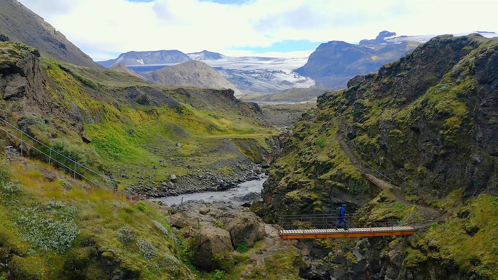
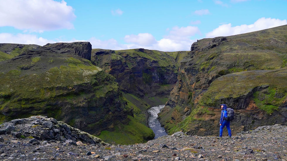
At the end of the ash desert, you have to cross the canyon of the Fremri-Emstrua glacial river before you finally reach one of Iceland's rare birch forests.


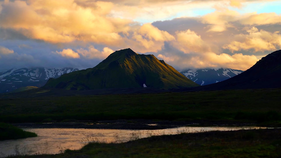
Day 3: On the third day, you'll have a strenuous climb up to Fimmvörðuháls. Fimmvörðuháls is a plateau in the south of Iceland that stretches between the glaciers Eyjafjallajökull in the west and Mýrdalsjökull in the east. Breathtaking views await you on this impressive section. Shortly before the plateau, there is a short passage secured by ropes, which in my subjective opinion - and I myself have a fear of heights - is only minimally exposed.
Due to the long distance and the sweaty altitude meters, I would like to recommend my ultra light hiking gear at this point:
Furthermore, I would like to recommend my beloved Salewa trekking shoes because of the challenging mountain trails and the often soaked meadows. For this trail, the shoes were a real blessing. One hundred percent waterproofness pays off here, but quality also has its price.
"Only where you have been on foot have you really been". Quote Johann Wolfgang von Goethe
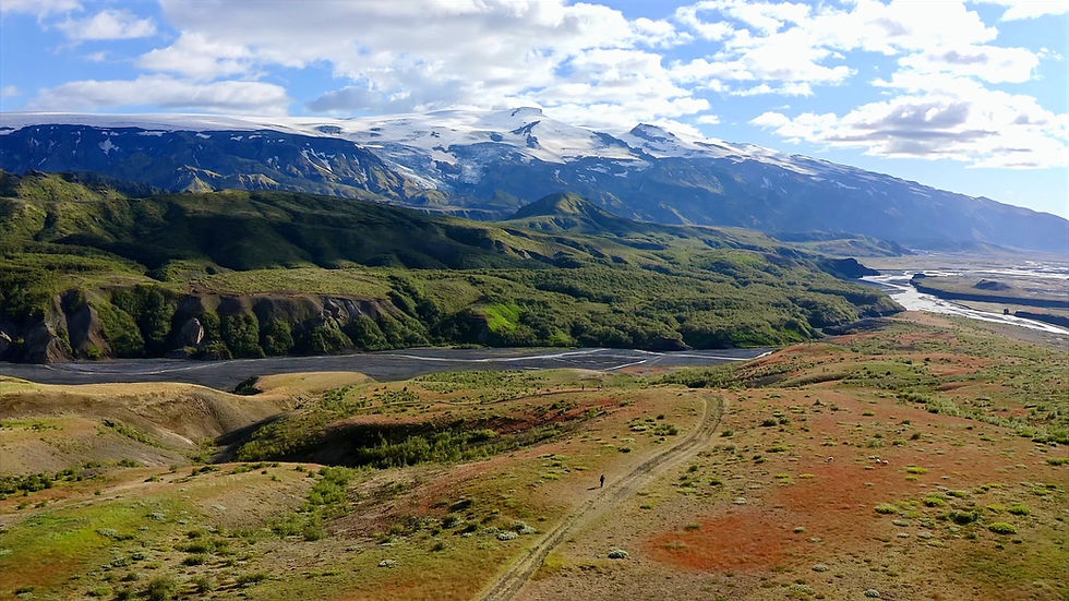
After the icy plateau, you then walk steadily downhill past countless beautiful waterfalls to Skogar. At the end, the impressive Skogarfoss awaits you, which you should definitely admire. You have reached your destination - congratulations! If you've made it, you deserve my full respect. It wasn't an easy journey, but it was unforgettably beautiful. This tour is one of my favourites!


Laugavegur trail huts
There is a hut about every 12-15 kilometres, which offers both food and accommodation. You can also pitch your tent in the huts for a fee. The following huts are available:
Landmannalaugar (starting point)
This hut is located at the start of the trail and offers sleeping accommodation and a hot spring for bathing. There is also a small shop there.
Hrafntinnusker
This hut is located about 12-15 kilometres into the hike. There are sleeping facilities and a campsite.
Alftavatn
The hut in Alftavatn is located by a beautiful lake and is a popular place to spend the night. There are also camping pitches and hot meals.
Emstrur (Botnar)
This hut is located near the river Emstrua and is an ideal place to take a break after the desert and river crossings. You will find sleeping accommodation and a campsite.
Þórsmörk
The end point of the trail, the hut in Þórsmörk, is one of the best-known huts on the trail. It is located in a beautiful valley landscape. There is also an outdoor sauna and hot meals.
Basar Hut
A little deeper in the valley near Þórsmörk, at the southern end of the Fimmvörðuháls pass, is the Basar Hut. This hut is also a popular accommodation for hikers tackling the Fimmvörðuháls Pass from Þórsmörk.
Fimmvörðuháls Hut
Located on the Fimmvörðuháls Pass, this hut offers basic facilities and is an important shelter on this route.
Skogar
In Skógar, a small town on the south coast of Iceland, there is both a hotel and a campsite.
Hotel: In Skogar there is a hotel as well as a campsite.
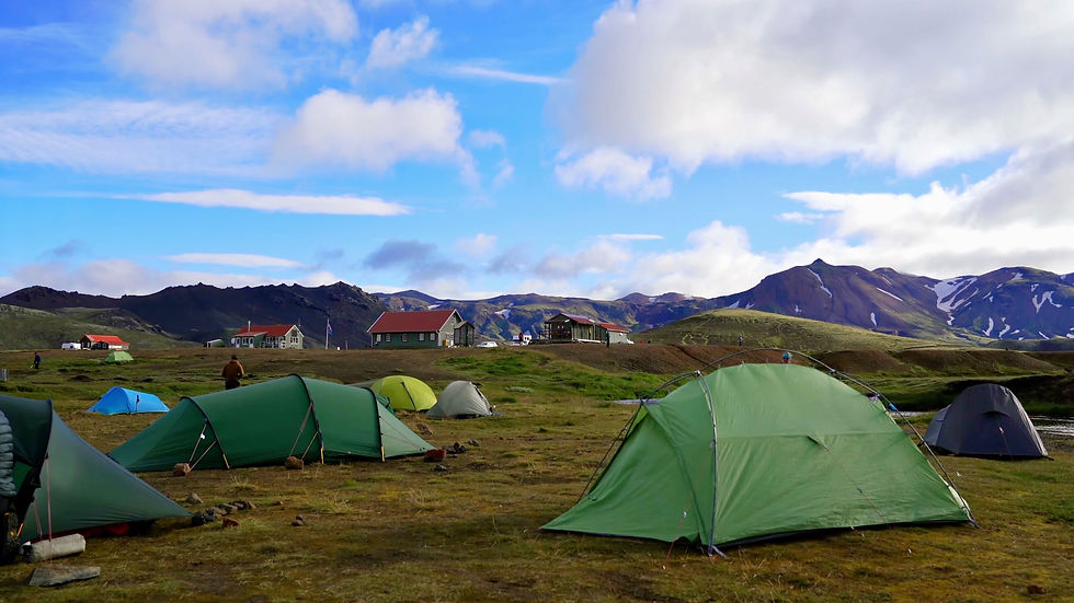
Laugavegur trail camping
There are well-equipped campsites with sanitary facilities along the route. You should bring wind and weatherproof equipment as conditions can often be rough. Wild camping is not permitted along the trail, so plan your overnight stays at the huts or campsites mentioned above.
Wild camping: Is not allowed in the nature reserve, i.e. along the entire trail.
Wetness: If there is a lot of wetness, the tent site should be well chosen to escape the wetness of the ground. I would recommend an additional ultralight groundsheet.
"A Scottish fog soaks an Englishman to the skin"

Hiking with children: I don't want to make a recommendation! During my hike, I met a few parents with their children. It could be an advantage that there is a hut with food and sleeping facilities every 12-15 kilometres. However, you should still do your own research before your hike, as there may be changes. Please note: The short, exposed passage at Fimmvörðuháls and the fords can be problematic.

For optimal preparation for any tours, I recommend the workouts on my Youtube channel:
Laugavegur trail weather and best time
In Iceland, you can often expect a mix of sun, clouds, wind, rain and snow. For me, the temperatures were always between 0 and 5 degrees. The best time to visit is definitely from the last week of July to the last week of August. There is very little snow then and the landscape really comes into its own. Overall, you can complete the trail from mid-June to mid-September.
Tip: Make sure that you don't undertake your hike during the ultramarathon. At this time of year, the trail is teeming with runners, marshals, guides and photographers. The original solitary and relaxing hiking adventure is then lost.
Laugavegur trail weather august
The Laugavegur Trail weather in August is generally mild but unpredictable. Temperatures range from 5°C to 15°C, but sudden rain, strong winds, and even snowfall can occur. River crossings may be affected by melting glaciers, making some sections more challenging. Be prepared with waterproof gear, warm layers, and wind protection. The Laugavegur Trail weather in August can offer beautiful sunny days, but conditions change rapidly.
Laugavegur trail weather september
The Laugavegur Trail weather in September is colder and more unpredictable than in summer. Temperatures drop to 0–10°C, with increased chances of rain, strong winds, and even snow. Be prepared with warm, waterproof gear, as conditions can change rapidly.
Laugavegur trail open
The Laugavegur Trail is usually open from late June to mid-September, depending on snow conditions. Outside this period, the trail becomes dangerous due to snow, river crossings, and harsh weather. Always check official updates before planning.

Laugavegur trail further information
Credit card: I was able to pay electronically at some of the huts.
Mobile phone reception: I had almost continuous network coverage.
Water: The water in the rivers is not drinkable due to impurities. It contains a lot of volcanic sediment. However, you can also fill up your water at the huts. The water is filtered there. In an absolute emergency, at least use a water filter. You should carry one with you on every longer hike anyway.
Tip: Stay in a Tent - the huts are more than full and must be reserved well in advance. With a tent you are more flexible. Please stay on the official campgrounds though, the Laugavegur Trail is completely in a nature reserve.
Catering: The food at the huts is unfortunately very expensive. I paid 46 euros for a simple chilli con carne. Yes, that's Iceland :/
Paths: The condition of the paths was very good along the entire trail. There are easy hiking trails, some of which are well-trodden with several lanes. Now and again there are gravel paths or mountain trails. At higher altitudes, the trail is covered in snow throughout the summer. However, the hiking trail was well marked with blue stakes.
Caution: In places you will have to cross snow-covered crevices in the ground, which can be hollow. It is therefore essential that you stick to markings and well-trodden paths. These usually lead you over areas where the fall height would not be so great if the snow cover collapsed. Avoid deviating from the paths to explore.

Surefootedness: To be safe on the trail, sure-footedness and the right footwear are the most important factors - after all, falls due to tripping and slipping are the most common cause of accidents when hiking. So remember: the right footwear and the right walking technique are therefore incredibly important. You are sure to find the right footwear in the article below!
Hazards: Here are the hazards to watch out for:
- volcanic activity
- heavy rain which makes the rivers swell quickly and makes fording impossible.
Please keep an eye on the warnings on vedur.is and on the huts.
For information about dangers of any kind, including volcanic activity, visit safetravel.is
Laugavegur trail race
The Laugavegur Trail Race is an annual ultramarathon covering the 55 km route between Landmannalaugar and Þórsmörk. While it's an impressive event, it significantly impacts the trail. Hundreds of runners, support teams, and race officials create a busy and crowded atmosphere. If you seek a peaceful hiking experience, it's best to avoid the trail on race day. The presence of aid stations, route markers, and the general excitement of the event make relaxed trekking difficult. Plan accordingly to fully enjoy the Laugavegur Trail without the race-day hustle.
Tip: Avoid the day of the ultra marathon
Laugavegur trail cost
The Laugavegur Trail cost itself is minimal, as the trail is free to hike. However, additional expenses include travel to Iceland, which typically costs between 100-150 euros. Campsites along the trail charge around 25 euros per night, and a warm meal in the huts costs about 50 euros. Overall, you can expect the total Laugavegur Trail cost to range from 350-500 euros, depending on your choices for accommodation and meals.
Laugavegur trail elevation gain
The Laugavegur Trail elevation gain is approximately 2,000 meters (6,600 feet) over its 55 km length. The trail features a mix of climbs and descents, offering challenging yet rewarding views.
laugavegur trail fimmvörðuháls
laugavegur trail hot springs
laugavegur trail iceland huts
laugavegur trail hut reservation
Long-distance hiking trails in Europe: 90 routes, all countries
Wild & adventurous: these are the most beautiful long-distance hiking trails in Europe.
Safety advice
All the safety rules of mountain sports also apply to hiking and trekking! You can find the safety rules in the link below:
Laugavegur Packing list
Here I recommend the most important hiking equipment that I own, have tested myself and have also bought myself. I pay a lot of attention to the weight and quality of my equipment. The equipment should simply feel good on longer tours and also be light. I can recommend the equipment for women because my wife uses it and it is basically the same as the equipment for men.
Note: Please keep in mind that the packing list is general and you will have to adapt it depending on the season and your needs!
Advertising note: These product links are affiliate links. If you buy something through one of these links, I will receive a small commission without you having to pay more. This is for the maintenance of my blog and you support me with my project, for which I am very grateful. Thank you very much!
Clothes
Hiking boots
Hiking shorts
Long hiking pants
Functional shirt
Hybridjacket
Fleece-jacket
Rain jacket
Functional underwear
Hiking socks
Other hiking equipment:
• Sun cap
Hiking backback (approx. 60 litres or as required)
by EXPED - unfortunately not available on Amazon.
• Backback - Ospray (was my old one and is also good)
Technology and orientation:
• Compass
• Headlamp
• GPS device or GPS watch if necessary
• Binoculars if necessary
Catering:
• Sweets to keep up morale :)
Health & first Aid:
• First Aid (small and light)
• Tape
• Bivouac
• Toilet paper
Other:
• Passport/Insurance certificate
• cash
• Gas cartridge
Film equipment:
• Camera
• Drone
• Tripod
• Clip

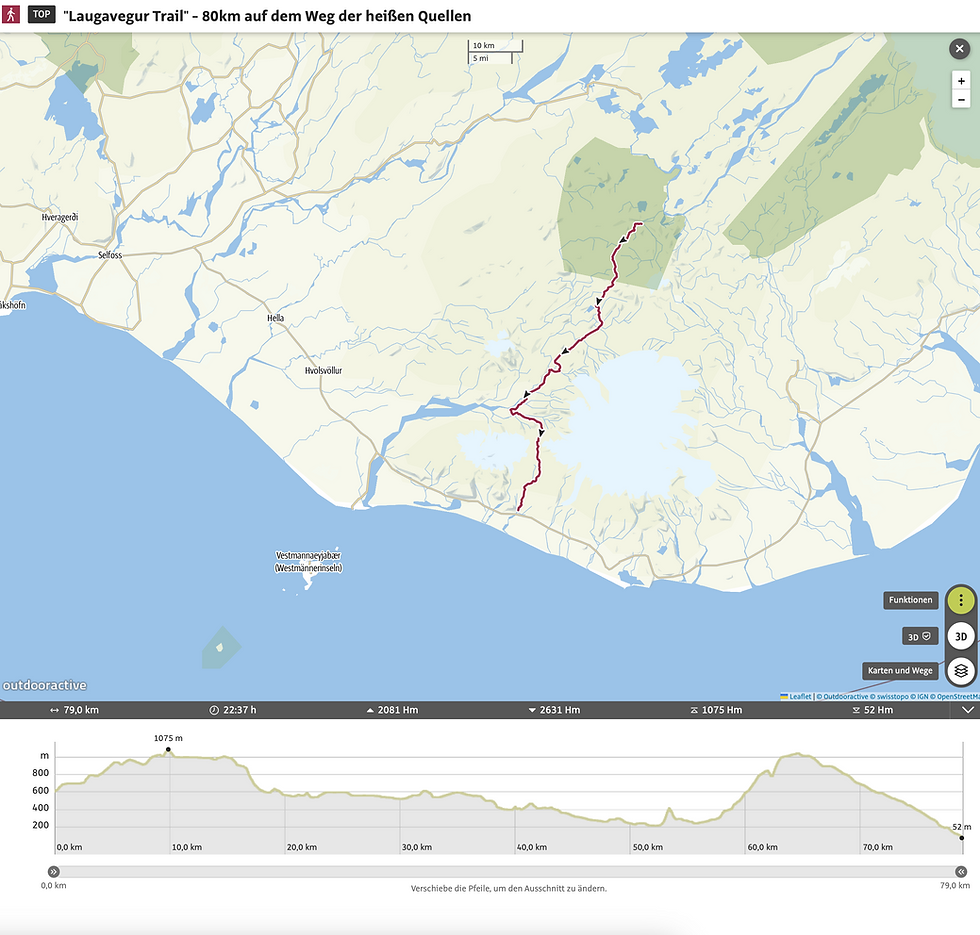
GPX and map information (Laugavegur trail map)
The GPX files are available for download on my pages from the following providers.
Outdooractive: https://out.ac/3vOAUO
laugavegur trail gpx download
Here is the route on the map (Madeira trail map):

Conclusion
The Laugavegur Trail with its length of 80km is a fantastic long distance hiking trail that offers an incredible amount. It shows a cross section of the beautiful landscape of Iceland. I really enjoyed the tour! The tour is definitely one of my favorites. Have a great time and good luck ;)
As always, I would be very happy about a feedback on one of my channels.
Also feel free to leave me a comment.

Hello, I am Christian, the chief globetrotter of this Site and an enthusiastic adventurer, hiker and filmmaker. I love to explore new paths and inspire people with them, and I love to share my hiking knowledge with you! You can also find my videos on YouTube! On my blog you can find tips for beginners and professionals on the greatest and most beautiful hiking tours there are. I want to encourage people to explore the world as a hiker, whether in the countryside, through the forest or in the mountains. True to the motto: If you haven't hiked, you haven't seen the world,
On my blog, I also write about hiking gear, the right summit training and nature conservation, as well as tips and information about hiking.
Thanks man